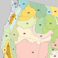
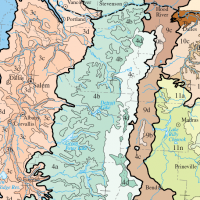
The Cascades ecoregion covers parts of Washington, Oregon, and California. Somewhat smaller than the Cascade mountain range for which it is named, the ecoregion extends north to Snoqualmie Pass, near Seattle, and south to Hayden Pass, near the Oregon-California border, including the peaks and western slopes of most of the High Cascades.
The mountainous region is underlain by volcanic rock that has been affected by alpine glaciations. The eastern part of the region contains active and dormant volcanoes in the Cascades Volcanic Arc, with elevations of up to 11,239 feet (3,426 m).
The western Cascades are older, lower, and dissected by numerous, steep-sided stream valleys. The region has a moist, temperate climate, which supports an extensive and highly productive coniferous forest that is intensively managed for logging, as well as recreational use. Subalpine meadows occur at higher elevations. (Source: Wikipedia)
The following table contains technical descriptions drawn from CEC Level III descriptions (document available below) produced for the EPA.
| TECHNICAL DESCRIPTION | WHAT IT MEANS | |
|---|---|---|
| LOCATION | Stretches from the central portion of western Washington, through the spine of Oregon, and includes a disjunct area around Mt. Shasta in northern California. | Mainly covers the mountainous region from the middle of Washington State through the Oregon Cascade range. |
| CLIMATE | The ecoregion has a mild to severe mid-latitude climate, varying by elevation, with mostly dry warm summers and relatively mild to cool very wet winters. The mean annual temperature ranges from approximately -1°C to 11°C. The frost-free period ranges widely from 5 to 180 days depending on elevation and latitude. The mean annual precipitation is 1824 mm, ranging from 1150 mm to 3600 mm. | Average temperatures range from 30°F to 52°F. Average annual precipitation is 72 inches, ranging from 45 inches to 142 inches a year. |
| VEGETATION | Extensive and highly productive coniferous forests. At lower elevations, Douglas-fir, western hemlock, western red cedar, big leaf maple, red alder. At higher elevations, Pacific silver fir, mountain hemlock, subalpine fir, noble fir, lodgepole pine. To the south, Shasta red fir, white fir. Subalpine meadows and rocky alpine zones occur at highest elevations. | This region is known for producing a lot of trees! Trees with needle-like leaves dominate this landscape. Lower, warmer parts of this zone have Douglas fir, western hemlock, western red cedar, big leaf maple and red alder trees. Higher, colder elevations have Pacific silver fir, mountain hemlock, subalpine fir, noble fir, and lodgepole pine. At the highest elevations you'll find meadows and rocky landscapes. |
| HYDROLOGY | Many intermittent and perennial streams in a dense drainage network; many alpine lakes; some large reservoirs at lower elevations. Water quality is high. | Some streams in the Cascades ecoregion flow only part of the year, and some flow all year. There are many streams and at high elevations there are many lakes. Artificial lakes behind dams exist at lower elevations in the region. Water quality is good. |
| TERRAIN | This mountainous ecoregion is underlain by Cenozoic volcanics and has been affected by alpine glaciations. It is characterized by steep ridges and river valleys in the west, a high plateau in the east, and both active and dormant volcanoes. Elevations range from about 250 meters upwards to 4,390 meters. Soils are mostly cryic and frigid temperature regimes, with some mesic at low elevations and in the south. Andisols and Inceptisols are common. | The Oregon Cascades are composed of rocks as old as 3.5 million years. Glaciers in the highest regions have carved various small basins, valleys, and left behind steep peaks and ridges. Steep landscapes dominate the western side of the Cascades and a high plateau dominates the eastern slope. Active and dormant volcanoes are common. Elevations range from about 820 feet above sea level to 14,403 feet. Soils range from very cold soils churned by frost to medium-textured well-drained soils. |
| WILDLIFE | Roosevelt elk, black-tailed deer, black bear, mountain goats in the north, cougar, coyote, beaver, river otter, mountain quail, pileated woodpecker, northern goshawk, mountain chickadee, northern spotted owl, chinook salmon, steelhead trout, bull trout. | Roosevelt elk, black-tailed deer, black bear, mountain goats in the north, cougar, coyote, beaver, river otter, mountain quail, pileated woodpecker, northern goshawk, mountain chickadee, northern spotted owl, chinook salmon, steelhead trout, bull trout. |
| LAND USE/HUMAN ACTIVITIES | Forestry, recreation, water supply for urban and agricultural areas in adjacent lowland ecoregions, a few areas of ranching and livestock grazing. Large areas are in public lands (national forests, national parks) and population density is relatively low. No cities occur in the region. Larger towns include Stevenson, Cascade Locks, and Oakridge. | Forestry, recreation, water supply for urban and agricultural areas in adjacent lowland ecoregions, a few areas of ranching and livestock grazing. Large areas are in public lands (national forests, national parks) and population density is relatively low. No cities occur in the region. Larger towns include Stevenson, Cascade Locks, and Oakridge. |
Download the U.S. EPA source document for the technical descriptions quoted above: CEC_LEVEL_III_Descriptions_US_May2010

